
How Does Google Maps Know There’s Traffic Ahead?
Learn how Google Maps detects traffic using navigation data, historical patterns, incident reports and AI to predict congestion and calculate ETAs.
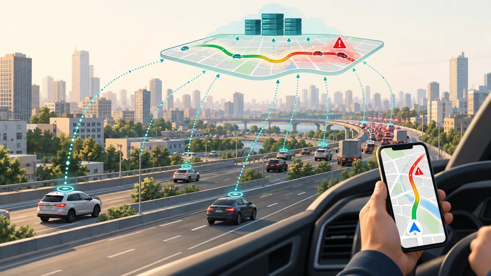
You leave home and open Google Maps.
The road immediately in front of you is clear, but Maps warns that there is heavy traffic 12 kilometres ahead. Part of your route turns red, your estimated arrival time increases by 14 minutes, and the app suggests another road that appears to avoid most of the congestion.
How can your phone possibly know what is happening kilometres away?
There isn't one giant Google traffic sensor watching every road.
Instead, Google Maps builds its picture from several kinds of information: navigation and location data from moving devices, historical traffic patterns, the road network itself, incident reports from drivers, information from partners and prediction models that estimate what conditions will be like by the time you reach a road.
Google says navigation data can include GPS location, the route being travelled and device sensor data. It uses such information, alone or combined with data from other users, to provide real-time traffic information and suggest faster routes.
That explains something important about the red traffic line on your screen:
It usually isn't reporting one person's experience.
It is the result of a much larger system trying to answer a continuously changing question:
How quickly is traffic moving on this part of the road, and how quickly is it likely to be moving when you get there?
Your Phone Can Become a Moving Traffic Sensor
Imagine 200 vehicles travelling along the same highway.
Many of the drivers are using Google Maps navigation.
Those phones know their own locations through technologies such as GPS, mobile networks, Wi-Fi and other positioning signals. While turn-by-turn navigation is active, Google says Maps can collect information including GPS location and the route taken.
Now think about what repeated location measurements reveal.
If devices move several kilometres along a highway in a few minutes, traffic is probably flowing reasonably well.
If many devices move only a few hundred metres in the same amount of time, something is probably slowing the road down.
No single phone needs to announce:
"There is a traffic jam here."
Collective movement can reveal it.
Google describes live Maps traffic as being informed by aggregate location data from people navigating with Google Maps.
Conceptually, the system can compare how traffic is moving with what is normal for that road and time.
That turns phones already travelling along the road into a distributed network of traffic observations.
But GPS Coordinates Alone Are Not Enough
There is an immediate technical problem.
A phone doesn't naturally report:
"I am in the second lane of National Highway X travelling east."
It produces a geographic position.
That position may also be imperfect.
GPS can drift. Tall buildings can reflect signals. Roads can run close together. A service road may sit only metres from the main carriageway.
So mapping systems need to associate location observations with the most likely road segment.
This general process is often called map matching.
Google publicly demonstrates this capability in its Roads API, which can take a sequence of GPS coordinates and "snap" those observations to the most likely road the vehicle travelled along. The exact internal traffic system used by consumer Google Maps is not fully published, but the principle illustrates how raw positions can be connected to the road network.
Once movement can be associated with road segments, the traffic problem becomes much more manageable.
Instead of asking:
Where are thousands of phones?
the system can ask:
What appears to be happening on this stretch of road?
How Does Google Maps Decide a Road Is Slow?
Suppose a road normally carries traffic at around highway speed at 11 a.m.
Today, movement observations suddenly indicate that vehicles are progressing much more slowly.
The system can infer that current traffic conditions differ from normal conditions.
Google's traffic layer represents this visually.
According to Google Maps Help:
- Green means no significant traffic delays.
- Orange indicates a medium amount of traffic.
- Red indicates delays.
- Darker red represents slower traffic.
These colours are not measurements of how "full" a road looks from above.
They represent traffic conditions and relative movement along road segments.
That is why a road can turn red even if Google has no satellite image showing a line of cars.
Satellite imagery is not the main mechanism being used to watch live traffic.
Google Maps Doesn't Only Need to Know What Traffic Is Like Now
Live observations solve only part of the problem.
Imagine your destination is one hour away.
There is a motorway 40 minutes into the journey.
At the moment you start driving, that motorway is moving normally.
But perhaps it becomes heavily congested almost every weekday around the time you will reach it.
If Maps looked only at current traffic, it could send you directly toward a jam that hasn't formed yet.
So Maps also needs to predict the future.
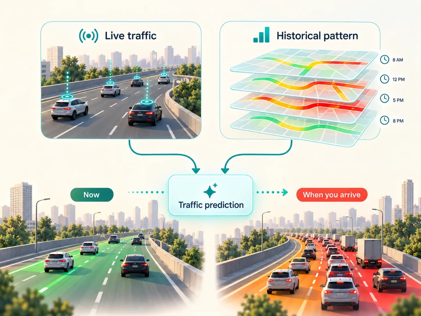
Google has explained that its traffic systems combine historical traffic patterns with live traffic conditions to estimate what traffic is likely to look like later in a journey.
Its current Routes documentation makes the same distinction: Google's traffic-aware routing can use both historical and live traffic, with live information becoming more important when the departure time is close to the present.
That is how Google Maps can sometimes warn:
"Traffic ahead"
even though traffic is flowing perfectly where you are now.
Historical Traffic Is Extremely Useful
Traffic is surprisingly repetitive.
A road may behave differently at:
- 7 a.m. on Monday
- 11 a.m. on Monday
- 6 p.m. on Monday
- 11 p.m. on Monday
- Sunday morning
Over time, a navigation system can learn patterns.
Perhaps one junction slows dramatically during the morning commute.
Perhaps a business district empties around 6 p.m.
Perhaps a motorway that is clear on Sunday becomes congested every weekday afternoon.
Google has described analysing historical traffic patterns for individual roads and combining them with current conditions to generate predictions.
Historical data therefore gives the system a baseline expectation.
Live data tells it what is happening now.
Prediction models try to work out what is likely to happen next.
Why AI Is Useful for Traffic Prediction
Traffic is not just a collection of independent roads.
A slowdown on one road can affect another.
Cars divert.
Intersections fill.
Queues propagate backwards.
A blocked lane on a major route can increase traffic on several surrounding streets.
That makes a road network well suited to computational models that consider relationships between connected road segments.
Google has publicly discussed using machine-learning techniques, including graph-based neural-network approaches, to improve traffic and ETA prediction.
The important point for a normal Maps user is not the specific model architecture.
It is that the app does more than say:
"Cars are moving slowly here right now."
It can attempt to predict:
"Given what is happening now, what usually happens at this time, and how neighbouring roads are behaving, what will conditions probably be when this driver reaches this section?"
That is a much harder problem.
Traffic Jams Are Not Detected Only From Phone Movement
Imagine a motorway is suddenly closed because of a crash.
There may be a delay before enough vehicles accumulate to make the slowdown obvious from movement alone.
That is where other information becomes useful.
Google Maps also receives incident information.
Drivers can currently report events including:
- crashes
- traffic slowdowns
- construction
- lane closures
- objects on the road
- flooded roads
- low visibility
Availability varies by country and platform. Google also allows users approaching some reported incidents to indicate whether the problem is still present.
Google announced in 2024 that incident information could come from both the Google Maps and Waze communities.
A report therefore gives the system another clue:
Something unusual may be affecting this road.
Governments and Other Partners Matter Too
Crowdsourced reports are not the only external source.
Google says Maps also obtains traffic and incident information from partners such as governments, organisations and businesses.
Partner data can provide structured information about things such as:
- road closures
- lane closures
- construction
- restrictions
- planned disruptions
Google's content-partner documentation, for example, defines formats through which road-closure and construction information can be supplied.
This can be especially useful for a planned closure.
Google does not need to wait until drivers physically arrive, stop and create a queue if an authoritative source has already supplied the road restriction.
A Traffic Prediction Is Built From Several Layers
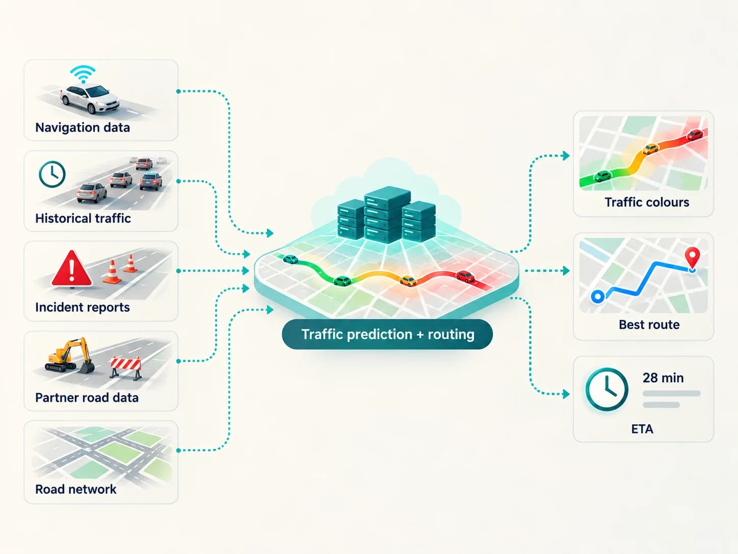
A simplified version of the system looks like this:
Moving-device navigation data
tells Google how roads appear to be moving now.
Historical traffic
tells it how those roads usually behave.
Incident reports
provide information about crashes, congestion, closures and other unusual events.
Partner data
adds authoritative information about roads and restrictions.
The road network
tells the system which roads connect and what alternative paths exist.
Prediction models
estimate what those conditions may become during your journey.
↓
Traffic estimate + route + ETA
None of those pieces is perfect by itself.
Together, they can create a surprisingly detailed model of what is happening across a road network.
How Does Google Calculate Your ETA?
Once Maps has estimated traffic conditions, it still has to answer a more personal question:
How long will your journey take?
A route is divided conceptually into road segments.
Each segment has characteristics such as distance and expected travel time.
Traffic changes the expected time required to pass through those segments.
Google's current Maps Platform documentation distinguishes between a route duration based on historical conditions and durations that also take real-time traffic into account. Its traffic-aware routing mode is described as equivalent to the traffic-aware approach used by Google Maps itself.
The system then combines the expected travel times along the route to generate an ETA.
But there is an extra complication.
Your ETA must evolve while you drive.
If a crash occurs 20 minutes into the journey, Maps may need to recalculate.
If congestion disappears faster than expected, the ETA can move earlier.
If your speed changes or you take another road, it adjusts again.
So the arrival time is not a static prediction calculated once at the beginning.
It is repeatedly updated as the trip changes.
Why Does Maps Sometimes Suggest a Longer-Looking Route?
Suppose Route A is 20 km.
Route B is 24 km.
The shorter route seems obviously better.
But Route A contains a heavily congested city road that will take 25 minutes to cross.
Route B uses a faster bypass.
The physically longer route may therefore take less time.
Google Maps says its route calculations can take live traffic conditions into account and perform a broader search across the road network to find a better traffic-aware route.
Distance is therefore only one part of routing.
The app is trying to minimise something closer to expected journey cost, especially travel time, rather than simply drawing the shortest possible line between two points.
How Can Google Know About a Jam That Hasn't Started Yet?
This is perhaps the most interesting part.
Imagine you are 45 minutes away from a major junction.
Currently:
Junction traffic: green
But historical data says the junction usually deteriorates rapidly around 5:30 p.m.
It is 4:55 p.m.
You are expected to arrive at 5:40.
Meanwhile, traffic on nearby roads has already started slowing slightly earlier than normal.
The prediction system may conclude that by the time you arrive, the road is likely to be congested.
So Maps can recommend another route now.
That is not the app somehow seeing into the future.
It is forecasting.
Much like weather forecasting, traffic prediction uses recent observations and historical patterns to estimate a future state.
And like weather forecasts, it can be wrong.
Why Google Maps Sometimes Gets Traffic Wrong
Anyone who uses Maps frequently has seen this happen.
A red road turns out to be almost clear.
A supposedly fast route becomes jammed.
An ETA suddenly jumps by ten minutes.
There are several reasons.
Not enough fresh data
A quiet road may have relatively few participating devices providing current observations.
The system then has less evidence about what is happening at that moment.
Traffic changes rapidly
A crash can occur seconds after a route is calculated.
A blocked vehicle can be moved.
A traffic signal can fail.
A stadium can suddenly release thousands of vehicles.
GPS isn't perfect
Location measurements contain uncertainty, particularly around tunnels, flyovers, dense buildings and parallel roads.
Human reports can become outdated
A reported incident may have been cleared.
Google asks users near some incidents whether they are still present partly because road conditions change.
Predictions are still predictions
Historical patterns describe what normally happens.
Today does not have to behave normally.
A public holiday, unusual weather, school closure, protest, event or roadworks can alter the pattern.
The app isn't displaying perfect knowledge of the road network.
It is displaying its best current estimate.
Does Google Maps Track Every Driver Individually?
This question needs a more careful answer than either "yes" or "no."
When you actively use navigation, Maps does need location information to know where you are and guide you.
Google's current help documentation states that navigation data can include GPS location, the route travelled and device sensor data. It says this information can be combined with other data to provide traffic updates and faster alternative routes.
But that does not mean the traffic layer displays identifiable individual drivers.
Google says updates derived from navigation data are not associated with a user's Google Account or device after processing, and that the navigation data needed for these Maps functions is deleted after processing.
Another current Maps help page says traffic estimates can use anonymous phone data combined with data from other phones so that individual devices cannot be identified in the traffic result.
That distinction matters.
Maps needs movement information to estimate traffic.
It does not need to show another Maps user that Akhil's phone is travelling at 23 km/h on this road.
The useful output is the aggregate condition:
traffic on this road is slow.
Google Maps Timeline Is a Different Thing
Traffic data is sometimes confused with Google Maps Timeline.
They are not the same feature.
Timeline is a personal history feature that can save places and routes you have visited. Google currently says Timeline is off by default and can be enabled or disabled by the user.
Navigation itself has separate data handling.
So turning on navigation does not mean the traffic system is simply reading a permanent personal diary of everywhere everyone has travelled.
Google's data systems and account settings are more complicated than that.
Does Maps Need Thousands of Users on Every Road?
No, but more high-quality observations generally make live estimation easier.
On a busy urban road, there may be plenty of movement information.
On a remote road, there may be little or no fresh traffic data.
In those cases, the system may rely more heavily on:
- historical patterns
- known road characteristics
- partner information
- nearby traffic
- available current observations
This is one reason traffic accuracy can vary dramatically from place to place.
A technology based partly on real-world observations works best where useful observations exist.
The Clever Part Is Not Detecting a Traffic Jam
If thousands of cars are barely moving, recognizing congestion is relatively straightforward.
The harder challenge is predicting what that traffic means for you.
Will the jam still exist when you arrive?
Will it become worse?
Will an alternative road also become congested after everyone diverts?
Is saving seven minutes worth taking a longer road?
Will a temporary closure disappear before you reach it?
Should your ETA change by two minutes or twenty?
That is where Google Maps becomes more than a coloured traffic map.
It becomes a continuously updated prediction system.
The familiar red line on your screen is therefore the visible output of many invisible steps:
Phones and navigation systems observe movement.
Those observations are associated with roads.
Traffic conditions are estimated.
Historical patterns provide context.
Incidents and partner data add additional information.
Prediction models estimate future conditions.
Routing algorithms compare possible paths.
Your ETA and route are updated.
So when Google Maps warns you about traffic ahead, it usually does not "see" the traffic in the way a person looking down from a helicopter would.
It infers and predicts it from data.
And by the time the road in front of you turns red, thousands of small digital clues may already have told the system that something farther ahead is going wrong.